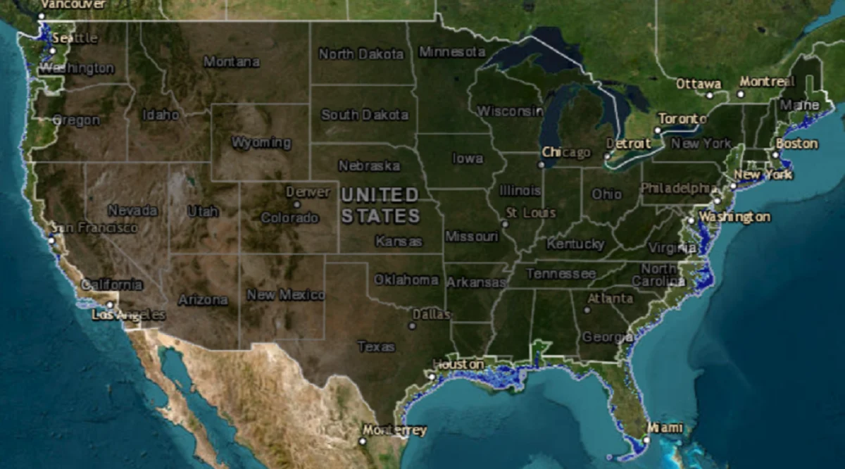
Imagine taking a road trip in the year 2100 and finding that the trusty old U.S. map in your glovebox is a relic, nothing more than a snapshot of a long-gone landscape. This isn’t a plot twist in a dystopian novel; it’s a very real possibility if sea levels rise as scientists are predicting.
The picture isn’t pretty: with a potential six-foot sea level surge, entire chunks of coastal America are at risk of becoming part of the Atlantic or the Gulf of Mexico. The Intergovernmental Panel on Climate Change (IPCC) warns that a rise of 43 to 84 centimeters is likely by the century’s end, and they’re not writing off an even more drastic two-meter jump.
“Sheet ice melting, particularly near the poles, drives sea level rise,” the IPCC highlighted, noting that Antarctica and Greenland are the main culprits with enough ice to elevate sea levels by 190 and 23 feet, respectively. So, if all the world’s ice melts, we’ll have a combined 216-foot increase.
While the complete meltdown scenario would unfold over millennia (which isn’t that long in reality), rising global temperatures are speeding up the process more than we’d like. The more global average temperatures increase, the more likely this is to occur.
What Stays, What Goes
Even if we dodge the total ice melt doomsday, the U.S. is still looking at some serious redraws. New York’s famous skyline? It could withstand a six-foot rise, but the whole city, plus Long Island, would be lost to the waves if all ice sheets melted. Florida’s iconic Keys? They’d vanish with just that six-foot rise.
North Carolina, South Carolina, Florida, and Louisiana face the harshest changes. Think of North Carolina without three of its coastal counties, Charleston neighborhoods turning into archipelagos, and Florida’s Cape Coral, St. Petersburg, and Tampa getting a serious trim. Miami-Dade would see its vibrant neighborhoods become part of the Atlantic’s seabed.
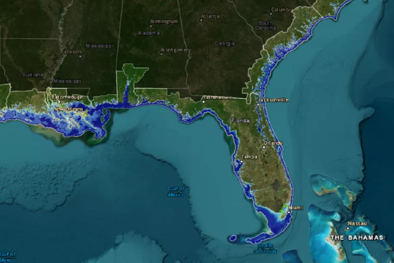
A map of what Florida's coastline would look if sea levels rise by six feet, with areas of new ocean denoted in blue.
Credit: NOAA
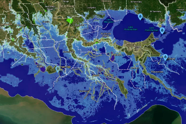
Louisiana would bid farewell to much of its low-lying charm, and New Orleans would hang onto the mainland by a slender land thread. Larose to Golden Meadow? That’s the Gulf’s newest island.
The Carolinas’ losses are severe, with whole areas predicted to slip underwater, forever reshaping the states’ identities.
If sea levels rise by 6 feet, the Louisiana coastline around New Orleans would look like the map above. The areas of new ocean are in light blue, with regions decimated by flooding in light green. Source: NOAA
Texas and Beyond
It’s not just the East in trouble. Texas’ coastal nooks, like Galveston, would also face the ocean’s encroachment. While the West’s mountainous terrain offers some resilience, no coastal area gets off scot-free.
National Geographic’s 2013 analysis paints an even more dramatic picture: an entirely submerged Florida, a significantly shrunken Louisiana, and the East Coast from the Carolinas to Virginia reshaped beyond recognition.
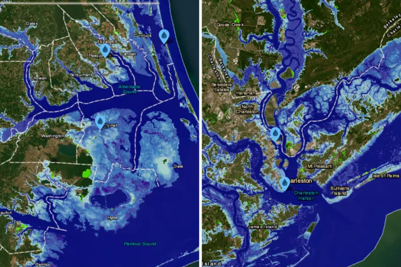
A depiction of the coastline in northern North Carolina (L) and (R) around Charleston, South Carolina, should the sea levels rise by 6 feet. Areas of new ocean appear in blue, and low-lying regions prone to flooding are in green.
Credit: NOAA
In a future where San Francisco’s hills might be solitary islands and California’s Central Valley a vast bay, the maps of tomorrow will tell the tales of choices made today.
The List: What Changes Most?
Florida’s Keys: Disappear entirely.
Monroe County, FL: Completely submerged.
New Orleans, LA: An almost island city, clinging to the mainland.
Charleston, SC: A city turned into a series of islands.
Miami-Dade County, FL: Neighborhoods under the sea.
Eastern Texas: Vulnerable coastlines, including Galveston.
The Carolinas: Vast areas lost to the ocean.
Delmarva Peninsula, East Coast: Consumed by the Atlantic.
Southern New Jersey: A large portion underwater.
California’s Central Valley: Transformed into an inland bay.
So, as the tide of change looms, it’s time to rethink not just our maps but our actions, aiming to steady the ship on this warming globe. The next century could see America’s geography – and its heart – forever altered.